Kluver Road under muddy floodwater
Looking south along Kluver Road from the truck. A single storm has put muddy, sediment-brown water completely across the pavement — the centerline disappears into the flood.


A contractor laydown yard for Phoenix Logistics — the construction company currently building the Project Maize data center in Michigan City, Indiana — is proposed for 19701 N Kluver Road, directly beside our farm. The photographs and video below were all taken in a single morning storm — each one pinned to the exact spot it was recorded. Watch where the muddy, polluted water goes.
A contractor laydown yard means cleared earth, gravel, stockpiled material, fuel, and heavy equipment — and almost no living ground to soak up a storm.
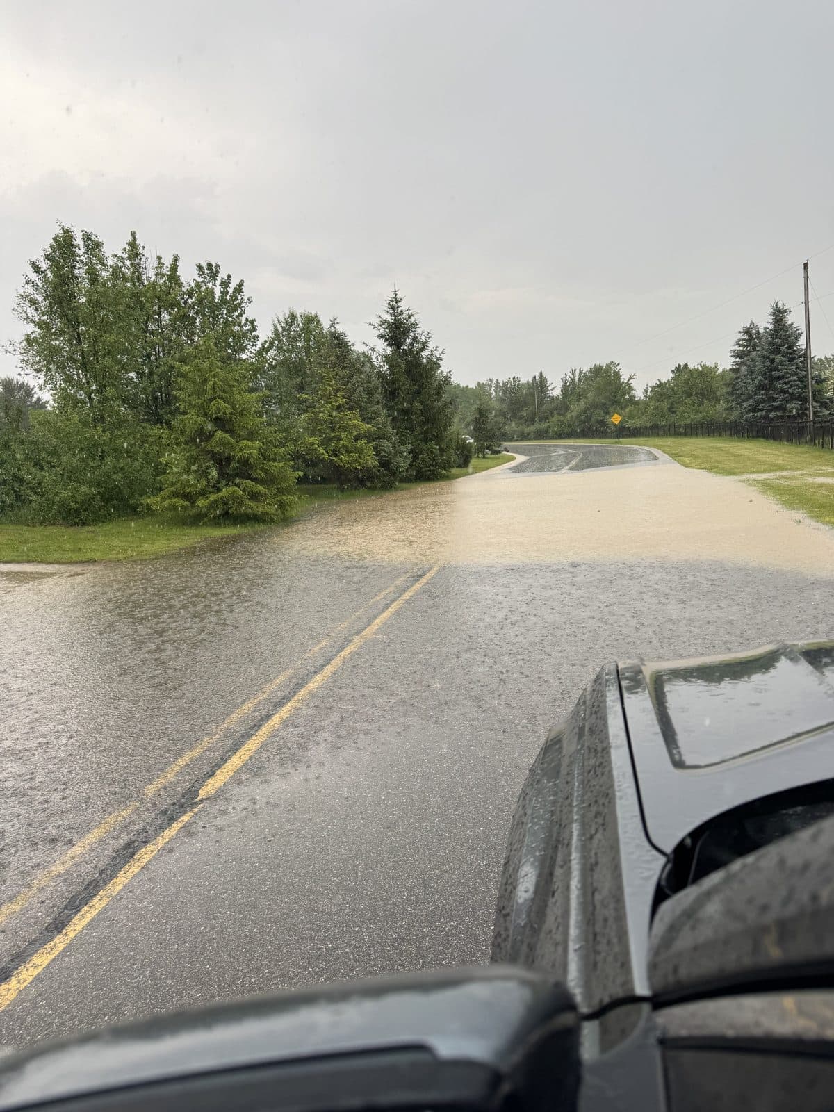
Phoenix Logistics is the construction firm building the Project Maize data center across the state line in Michigan City, Indiana. A laydown yard is the staging ground for that construction work: bulk materials, fuel, gravel, stockpiled steel and concrete, heavy equipment, and fuel trucks. To make room, the existing soil and ground cover are cleared and the surface is graded flat. The result, as the photos below show, is a parcel with almost no remaining capacity to absorb a storm.
When it rains on a site like that, water doesn't sink in. It sheets off, picks up sediment and whatever else is on the ground, and runs to the lowest point it can find. Here, that low point is Kluver Road and the farmland and wetlands below it.
On the morning of June 6, 2026, we walked the road during a single rain event and documented what came off the proposed site. The water was thick with sediment. A straw-bale filter meant to catch it was already overwhelmed. Within minutes the runoff had crossed the road and was pooling and channeling onto neighboring property.
This is the routine, everyday reality of approving a laydown yard on this parcel — not a worst case. It is simply what happens when it rains.

Sediment-laden runoff flowing around a straw-bale filter that was meant to stop it.
Each marker sits at the GPS coordinate embedded in the original photo or video. Click a marker to see what was happening at that spot. The numbers run north → south, following the water downhill from the proposed laydown yard toward our land.
Tip: switch between satellite and map view using the layers control at the top-right of the map. Drag to pan, scroll or pinch to zoom.
The same evidence as on the map, in order from north to south — following the runoff downhill. Click any image to view it full size or play the video.
Looking south along Kluver Road from the truck. A single storm has put muddy, sediment-brown water completely across the pavement — the centerline disappears into the flood.
Driving slowly past the site. Tan, sediment-laden water sheets across Kluver Road from the graded ground on the laydown-yard side; a worker in a safety vest is visible at the tree line.
The site's erosion control: a single straw bale. Muddy runoff is pouring around and past it onto the gravel — the filter is already overwhelmed during an ordinary rain.
Where the gravel meets the green field, the storm has left standing water and a fresh layer of silt washed down from the graded ground upslope.
Sediment-brown water pools and runs along the edge of the gravel drive at the tree line — the same color of water, now on the ground at the boundary of our property.
The roadside ditch is running full of muddy brown water, carrying the discharge south — downhill, toward the farm and the wetlands below.
The photos above were taken before the site is even in operation. A working contractor laydown yard would make this the new normal for everyone downhill.
Sediment, fuel, and contaminants wash directly onto working farm fields and pasture immediately downhill — degrading soil and water our operation depends on.
Runoff drains toward low-lying wetlands and the shallow water table near the Michigan–Indiana line, carrying whatever leaves the yard with it.
Kluver Road was submerged in a single storm. More impervious, graded ground upstream means more water, more often, on a road neighbors rely on.
Sediment-laden discharge doesn't stop at the property line. It continues through ditches and drainage toward the streams and lakes this watershed feeds.
The single straw-bale filter on site was already overwhelmed during a routine rain. Erosion controls that fail before operations begin will not hold up under daily use.
Heavy equipment, noise, dust, and truck traffic next to homes and farmland are incompatible with the rural, agricultural character of this stretch of New Buffalo Township.
The decision is not abstract. The water in these photos is real, it is documented, and it is already crossing property lines. Your voice before the Planning Commission is what keeps this evidence in front of the people making the decision.
Attend the hearing and ask the Commission to deny or require a full stormwater and erosion-control review before any approval.
Submit a written comment — even a few sentences. Reference what these photos show: polluted runoff leaving the site and reaching neighboring farmland during a single storm.
Share this page . Send the link to neighbors, fellow landowners, and anyone who cares about clean water in this watershed.